Existing Legislation and Policy Levers
Existing Legislation and Policy Levers for Local Governments
Local governments have policy tools they can use to integrate environmental information and protection into their land use planning and decision-making with the goal of advancing climate adaptation actions. These tools range from federal and provincial legislation to Official Community Plans (OCPs), strategies, and bylaws, which can all be utilized by local governments.
At this time, local governments are not using the full extent of existing powers for protecting and restoring the natural environment. The goal of this toolkit is to help change this by describing the legislative and policy tools currently available to local governments within their existing authorities, and ways these can be used to support climate adaptation and protection of biodiversity.
Local governments can use the legislation, programs and planning tools listed below which are created at different scales of government.
Federal Legislation and Programs
Species at Risk
Species at risk are plants and animals (including amphibians, birds, fish, fungi, invertebrates, mammals, plants, plant communities, and reptiles) that are native to Canada and are in danger of becoming extinct or extirpated from Canada. The purpose of the Species at Risk Act (SARA) (1) is to prevent these species from disappearing from Canada. SARA only addresses species at risk, not ecological communities at risk. At present, there are 200 endangered or threatened species in BC listed under SARA Schedule 1 (2 & 3).
When a species is listed on SARA Schedule 1, general prohibitions apply in certain circumstances, for example;
- no person shall kill, harm, harass, capture or take an individual;
- possess, collect, buy, sell or trade an individual, or any part or derivative;
- or damage or destroy the residence of one or more individuals.
Note – These prohibitions do not apply to SARA-listed species of special concern.
Prohibitions within SARA apply only on federal lands, with two exceptions: migratory birds listed under the Migratory Birds Convention Act are protected anywhere in Canada (as are their residences), and aquatic species and their residences are protected anywhere they occur (4).
Local governments do not have explicit legal responsibilities for the conservation of species at risk under SARA. Similarly, there are no approved federal or provincial policies yet regarding critical habitat for species listed under SARA. However, local governments must ensure they do not violate provincial and federal legislation, and should apply due diligence for actions and decisions that may facilitate violations by other parties (5) such as developers or permit applicants. This includes ensuring that Qualified Environmental Professionals have the appropriate expertise for the species they are surveying.
Although there are limited legal requirements for local governments to protect species at risk (with the exception of species protected under the Fisheries Act and the provincial Wildlife Act), protecting the habitat of species at risk brings economic, social, and cultural co-benefits through ecosystem services. Local governments can and do embed this in their biodiversity and climate adaptation strategies.
For a comprehensive discussion on considerations for local governments regarding SARA and species at risk, see the Green Bylaws Toolkit, section 29.4.
Federal Habitat Stewardship Program
The Habitat Stewardship Program for Species at Risk (HSP) was established in 2000. It provides funding for projects submitted by Canadians that contribute directly to the recovery objectives and population goals of species at risk listed on SARA Schedule 1, and that prevent other species from becoming a conservation concern.
Environment and Climate Change Canada administers HSP funds that support terrestrial stewardship projects, while Fisheries and Oceans Canada is responsible for projects for aquatic SAR.
The HSP issues a call for applications annually. Local governments can partner with other organizations to submit proposals and access funds. For more information, go to Habitat Stewardship Program for Species at Risk.
References
- Species at Risk Act, S.C. 2002, c. 29
- Species at Risk Act SCHEDULE 1, List of Wildlife Species at Risk, https://laws.justice.gc.ca/eng/acts/s-15.3/page-10.html, accessed 21 Jan 2025.
- BC Species & Ecosystems Explorer, https://a100.gov.bc.ca/pub/eswp/ search.do?method=process&searchType=COMBINED&sara=Y, accessed 22 Jan 2025.
- Species at Risk Act, ss. 34 and 58.
- Curran et al, pg. 329.
Migratory Birds Convention Act
The Migratory Birds Convention Act (MBCA) (1) provides:
- legal protections for migratory birds, including their eggs and their nests anywhere they are found, regardless of landownership.
- prohibits the possession or sale of migratory birds or nests, and the deposit of substances harmful to migratory birds in waters or areas frequented by them, unless authorized to do so.
- regulates the hunting of migratory birds, and prohibit the disturbance, destruction or taking of a migratory bird nest, egg, nest shelter, eider duck shelter or duck box, except in accordance with a permit (2).
Local governments need to comply with the protections in the MBCA and its regulations, these protections can be used to inform local government bylaws and policy. Some municipalities have an explicit provision that a tree-cutting permit will not be issued for a tree that is host to birds protected under the MBCA. For an example, see the City of Abbotsford’s Tree Protection Bylaw section 3(2).
Local governments are not limited to the protections found in the MBCA, and they may enact stronger protections for migratory birds on lands within their jurisdiction, as long as protections are not counter to senior government legislation. The City of Delta has a Birds & Biodiversity Conservation Strategy (2018) that sets out goals and objectives for the protection of birds and their habitat, and its OCP identifies critical shorebird habitat as Environmentally Sensitive Areas (3).
Although the MBCA offers protection for migratory birds, nests and eggs, it offers very little protection for migratory bird habitat. Local governments can strengthen habitat protections through Environmental Development Permit Area (EDPA) requirements and other measures such as establishing Key Biodiversity Areas (4).
For more information on how local governments can protect birds, nests and habitat through their bylaws, see the Green Bylaws Toolkit sections 7.7 and 9.6.
References
- Migratory Birds Convention Act, 1994, SC 1994, c. 22.
- Curran et al, s. 29.3, pg. 309
- City of Delta, 2024, Official Community Plan: Housing Our Future, https://delta.civicweb.net/filepro/documents/?preview=230680, accessed 10 Feb 2025.
- Curran et al, s.29.3, pg. 309
Fisheries Act
The Fisheries Act (1) regulates fishing, and protects fish and fish habitat, whether they occur on federal, provincial, other public, or private land. It prohibits
“the carrying on of a work, undertaking or activity that results in serious harm to fish that are part of or support a commercial, recreational or Aboriginal fishery.”
The Act defines “serious harm to fish” as the death of fish or the permanent alteration to, or destruction of, fish habitat, with fish habitat being spawning grounds and/or nursery, rearing, food supply and migration areas for fish.
For local governments, Fisheries Act requirements are applied in BC through the Riparian Areas Protection Regulation (RAPR) under the provincial Riparian Areas Protection Act. The RAPR sets out the minimum requirements that local governments must meet in protecting fish habitat. Fisheries and Oceans Canada has adopted the position that a landowner or developer may meet their Fisheries Act obligations in respect of protecting fish habitat by fully implementing the recommendations of a Qualified Environmental Professional who has followed the requirements of the RAPR (2); hence, local governments should embed RAPR requirements in their permitting processes.
Local governments should also make sure they are aware of any critical habitat that has been identified for aquatic species within their jurisdiction by the federal government. If a Ministerial Order under SARA or the Fisheries Act is in place to protect critical habitat, its destruction is considered an offence. Local governments may use this information in considering its Development Permit Areas (DPAs) or placing conditions on permits. “Critical Habitat Orders” and “Critical Habitat Protection Statements” can be found on the Species at Risk Public Registry website (3).
References
- Fisheries Act, R.S.C., 1985, c. F-14, https://laws-lois.justice.gc.ca/eng/acts/f-14/, accessed 24 Jan 2025
- Curran et al, s. 29.3, pg. 312.
- Government of Canada, Species at risk public registry, https://www.canada.ca/en/environment-climate-change/services/species-risk-public-registry.html, accessed 21 Jan 2025.
Net-Zero Emissions Accountability Act
Canada has legally committed to achieve net-zero emissions by 2050, and has set an emissions reduction target to be achieved by 2030 of 40-45 percent below 2005 levels. The federal government has announced significant investments and measures to help achieve this result. It has enshrined its 2030 climate targets under the Canadian Net-Zero Emissions Accountability Act (CNZEA) (1), which establishes robust accountability structures, including reporting obligations, to support the achievement of these goals (2).
While the CNZEA does not require compliance on targets by other levels of government, it does ask them for input regarding establishing targets and objectives, and binds the federal government to report on agreements and key cooperative measures undertaken with provinces and other governments. Local governments have an important role to play in reducing emissions, and many have already aligned with Canada’s 2050 net-zero target in their own climate related policies. Local measures include those that protect carbon storing ecosystems such as forests and wetlands, and protecting riparian areas and enhancing urban forests for climate resilience (3).
References
- Canadian Net-Zero Emissions Accountability Act, S.C. 2021, c. 22, https://laws-lois.justice.gc.ca/eng/acts/c-19.3/fulltext.html
- Government of Canada website, “Canadian Net-Zero Emissions Accountability Act”, https://www.canada.ca/en/services/environment/weather/climatechange/climate-plan/net-zero-emissions-2050/canadian-net-zero-emissions-accountability-act.html, accessed 15 Jan 2025.
- Environment and Climate Change Canada, “Exploring Approaches for Canada’s Transition to Net-Zero Emissions: Canada’s Long-Term Strategy Submission to the United Nations Framework Convention on Climate Change”, https://unfccc.int/sites/default/files/resource/LTS%20Full%20Draft_Final%20version_oct31.pdf , accessed 15 Jan 2025.
Canada's 2030 Nature Strategy
In 2022, following a four-year consultation and negotiation process, Canada and several other nations became a signatory to the Kunming-Montreal Global Biodiversity Framework (KMGBF). The KMGBF sets out 23 targets and four overarching goals to halt biodiversity loss, promote ecosystem restoration, ensure sustainable use of natural resources, and enhance the equitable sharing of benefits from biodiversity, especially for Indigenous Peoples (Figure 1). In adopting the KMGBF, all parties committed to setting national targets to implement it, while others were invited to develop and communicate their own commitments.
In 2024, Canada established its 2030 Nature Strategy to chart a path for how Canada will implement the KMGBF. The 2030 Nature Strategy builds on existing initiatives in all regions and sectors across the country, recognizing that these efforts have not been and will not be enough, as biodiversity continues to decline in Canada. It adopts a vision to be achieved by 2050 that serves as a guide for actions (1). Figure 2 presents this vision and the other elements of the 2030 Nature Strategy. Many of these elements are useful for local governments to include in their own climate and biodiversity strategies. The strategy aims to get everyone involved, including all levels of government, organizations, and individuals. It recognizes that local governments are important land managers, local experts, and land-use planners; that they have a direct connection to citizens, and are instrumental in connecting those citizens with nature. While there is no legal mechanism requiring local governments to adopt the strategy, its elements provide an excellent framework they can adopt for their own policies (2).
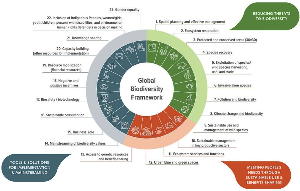
Figure 1 Schematic of the Kunming-Montreal Global Biodiversity Framework goals and targets (source: Government of Canada)
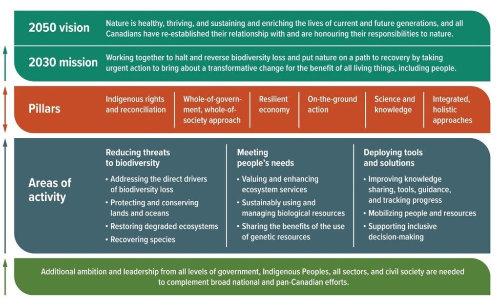
Figure 2 Main elements of Canada’s 2030 Nature Strategy (source: Government of Canada)
References
- Government of Canada, Canada’s 2030 Nature Strategy: Halting and Reversing Biodiversity Loss in Canada, https://www.canada.ca/en/environment-climate-change/services/biodiversity/canada-2030-nature-strategy.html#toc1, accessed 24 Jan 2025.
- Ray, J, 2024, “Connecting Canada’s 2030 Nature Strategy to the Global Biodiversity Framework”, op-ed in Wildlife Conservation Society Canada website, https://wcscanada.org/newsroom/stories/the-goals-and-targets-of-the-kunming-montreal-biodiversity-framework-kmgbf/, accessed 24 Jan 2025
Provincial Legislation and Programs
Climate Change Accountability Act and Local Government Climate Action Program
In 2018, BC enacted its Climate Change Accountability Act (1), which sets out targets for reducing greenhouse gas emissions 40% below 2007 levels by 2030, 60% by 2040, and 80% by 2050. The act also required all public sector organizations to be carbon neutral by 2010 and for each subsequent year.
The province established sector specific emission reduction targets for four sectors to help reach the 2030 target, including transportation, oil and gas, industry, and buildings and community. Local governments can particularly contribute to emissions reductions under the last sector through land use policies and decisions that aim to conserve and enhance high carbon ecosystems, such as forests and wetlands.
The act also created the Climate Solutions Council, a group with representatives from Indigenous communities, local governments, industry, universities, youth and businesses. The council gives government independent advice about climate action. (2)
CleanBC is the provincial government’s plan on lowering climate-changing emissions by 40% by 2030 by working with First Nations, local governments, the federal government, and a broad range of organizations and sectors. As part of CleanBC, the province established the Local Government Climate Action Program (LGCAP), which provides local governments and Modern Treaty Nations with predictable and stable funding to allow for cost-effective, impactful, locally implemented climate action. (3)
The LGCAP funding is available to participating local governments and Modern Treaty First Nations for initiatives that reduce GHG emissions and/or support adaptation and mitigate climate-related risks. Under the LGCAP, ‘climate action’ includes but is not limited to: climate-related hazards; integrating climate change measures into policies, strategies and planning; improving education, raising awareness of climate change causes and solutions, increasing human and institutional capacity with respect to climate change mitigation and adaptation, and impact reduction and early warning systems.
To qualify for LGCAP funding, local governments must be signatories to the BC Climate Action Charter, a voluntary agreement between the BC government, the Union of BC Municipalities, and each local government signatory to take action on climate change. Since launching in 2007, almost every local government in BC has become a signatory.
References
- Climate Change Accountability Act, SBC 2007 CHAPTER 42, https://www.bclaws.gov.bc.ca/civix/document/id/ complete/statreg/07042_01, accessed 29 Jan 2025.
- [1] Government of BC, 2021?, CleanBC Roadmap to 2030, https://www2.gov.bc.ca/assets/gov/environment/climate-change/action/cleanbc/cleanbc_roadmap_2030.pdf , accessed 29 Jan 2025.
- BC Government website, “Local Government Climate Action Program”, https://www2.gov.bc.ca/gov/content/ environment/climate-change/local-governments/local-government-climate-action-program, accessed 29 Jan 2025.
Wildlife Act
BC’s Wildlife Act(1)establishes licensing regimes and acceptable practices for hunting, trapping, and fishing in BC. It provides for the designation of extirpated, endangered, and threatened species, although to date there are only four designated species listed (i.e., Vancouver Island Marmot, Burrowing Owl, American White Pelican and sea otter). It prohibits the disturbance of species and wildlife habitats (i.e., wildlife management areas on Crown land, designated by BC Cabinet) and the killing, trading, trafficking, and transport of individuals of a designated species. The Wildlife Act also prohibits disturbing a muskrat or beaver house or dam, and taking or disturbing a bird, its egg, or a nest when a bird or egg is occupying it, making specific reference to eagles, peregrine falcons, gyrfalcons, ospreys, herons, and burrowing owls.
These general prohibitions apply on all lands in the province, including private and local government-owned lands and local governments must comply with them.(2) Local governments can also use these requirements to guide their own policies, such as EDPAs.
References
[1] Wildlife Act, RSBC 1996, c 488, https://www.bclaws.gov.bc.ca/civix/document/id/complete/statreg/96488_01, accessed 7 Jan 2025.
[2] Curran, GBTK s. 29.4, pg. 321
Endangered Species and Ecosystems
BC has no endangered species legislation or ratified policy on protecting endangered species and ecosystems with the exception of the Wildlife Act, which currently lists four species, only one of which occurs in the project area (Vancouver Island Marmot).
The Canada-British Columbia Agreement on Species at Risk sets out how the provincial and federal government will collaborate on the development of species and ecosystem at risk recovery plans. The recovery plans include actions to help stop or reverse the decline and remove threats to long term survival. The province focuses delivery of actions on Crown land rather than private land. The recovery plans are linked to the work undertaken by the BC Conservation Data Centre (CDC), which ranks species and ecosystems as red-listed (extirpated, endangered, or threatened in BC) or blue-listed (of special concern in BC) based on the degree of threat. While these designations have no legal consequences,—they provide information that should be used to guide land-use and management decisions and should be referenced by Qualified Environmental Professionals (QEPs) undertaking environmental site assessments.
The provincial Wildlife Act protects virtually all vertebrate animals from direct harm, except as allowed by regulation (e.g., hunting or trapping). However, it provides no protection for invertebrates (e.g., butterflies, bees, snails) or plants, and limited protection for habitat. Local governments that wish to embed protection for endangered species and ecosystems in policies and decision-making will need to make use of other tools, such as Development Permit Areas, aspects of the Wildlife Act, and potentially the Riparian Areas Protection Regulation (RAPR).
To protect sensitive ecosystems and ecosystems that support species at risk local governments can include policy in their Official Community Plan that indicates their intent to protect terrestrial and aquatic Environmentally Sensitive Areas (ESAs) as mapped or identified by a Registered Professional Biologist. The ESA maps would be included in the OCP appendices and would be linked to guidelines in and Environmental Development Permit Area to enable these areas to be protected through the permitting system.
Housing Statutes (Residential Development) Amendment Act (2023)
In 2023, the BC government brought into force the Housing Statutes (Residential Development) Amendment Act (“Bill 44”)(1) as part of its approach to addressing housing shortages. The act makes several significant amendments to the Local Government Act to enable more housing density, in part by allowing more units on traditional single-family and duplex lots. Some of the LGA amendments were enabled through the new Local Government Zoning Bylaw Regulation, which was brought into force in December 2023. Bill 44 mandated local governments to amend their zoning bylaws to comply with new small-scale multi-unit housing (SSMUH) density requirements by June 30, 2024. Essentially, the province required local governments to rezone all single-family properties. To help local governments understand and comply with these legislative changes, the province released the (“the manual”), which deals with SSMUH.(2) Provincial Policy Manual & Site Standards (“the manual”), which deals with SSMUH.(3)
Concerns have been raised regarding environmental implications of the new zoning requirements and whether they supersede or conflict with overlapping provincial legislation, such as the Riparian Areas Protection Regulation (see section 4.3.5), and/or environmental regulations put in place by local governments. However, the legislation and the manual are clear:
- For riparian areas, the SSMUH legislation does not supersede RAPR or measures put in place to meet or exceed provincial standards. If a proposed SSMUH development conflicts with overlapping provincial legislation, the provincial legislation takes precedence.(4)
- For DPAs, the SSMUH legislation allows local governments to continue to use them provided they do not unreasonably restrict the ability to use land at the use or density prescribed by the legislation provisions (see Section 457.1 of the SSMUH legislation, which applies the corresponding section of the LGA).
This means that local governments can continue to direct development away from areas of a parcel determined to be of ecological significance, require mitigating measures to avoid harmful impacts, and/or require compensatory measures if impacts cannot be avoided. It would not be appropriate, however, for a local government to implement an EDPA that would have the effect of preventing SSMUH forms of housing from being developed in the absence of site conditions and objectives that legitimately warrant it.”(5)
- Essentially, a local government cannot use the following regulatory powers to unreasonably prohibit or restrict the SSMUH density:
- development permit areas;
- development permits;
- temporary use permits;
- development variance permits;
- tree cutting permits;
- zoning bylaws;
- phased development agreements;
- runoff control bylaws;
- flood plain bylaws;
- sign bylaws;
- screening and landscaping bylaws
- heritage alteration permits; and
- heritage conservation areas.(6)
This does not mean that the regulations listed above will not apply to SSMUH developments. Rather, those regulations cannot “unreasonably prohibit or restrict” the SSMUH density. If an SSMUH development permit decision goes to court, it is possible that a court will find that an unreasonable prohibition or restriction is one that is not based on any rational analysis and that is not justified in the circumstances. For example, it would be reasonable for a local government to restrict tree cutting in connection with an SSMUH development in accordance with its tree bylaw.(7) This makes a strong case for local governments ensuring that the rationale for their policies and regulations are well-documented and based, as applicable, in science. For a legal analysis of the SSMUH regulations, refer to Small-Scale Multi-Unit Housing Zoning: Legislation and Best Practices (Enns 2024).
Some municipalities received specific Ministerial Orders specifying density increases, which could impact biodiversity. Local government response should be balanced with other provincial initiatives that prioritize biodiversity and ecosystem health, such as the Union of BC Municipalities’ resolutions calling for a Biodiversity Act in BC (2022), and the province of BC’s Climate Preparedness and Adaptation Strategy (Actions for 2022-2025).
References
- Bill 44 Housing Statutes (Residential Development) Amendment Act 2023.
- Government of British Columbia, 2023, Provincial Policy Manual & Site Standards, https://www2.gov.bc.ca/assets/gov/housing-and-tenancy/tools-for-government/local-governments-and-housing/ssmuh_provincial_policy_manual.pdf
- Government of British Columbia, 2023, Provincial Policy Manual & Site Standards, Part 1, s. 7.9, pg 25.
- Government of British Columbia, 2023, Provincial Policy Manual & Site Standards, Part 3, s. 1.3, pg. 50.
- Enns, J., 2024, Small-Scale Multi-Unit Housing Zoning: Legislation and Best Practices, report prepared for the Lidstone & Company Housing Needs – Legal Workshop held February 7, 2024, 192 pp.
- Enns, J., 2024, s. 2.3, pg 10.
- Riparian Areas Protection Act, SBC 1997, CHAPTER 21, https://www.bclaws.gov.bc.ca/civix/document/id/ complete/statreg/00_97021_01, accessed 7 Jan 2025.
Riparian Areas Protection Act and Regulation
The Riparian Areas Protection Act (RAPA)(1) and Riparian Areas Protection Regulation (RAPR) require certain areas of BC (all local governments within the project area except Alberni-Clayoquot Regional District) to protect fish-bearing watercourses during residential, commercial and industrial development. The goal of RAPR is to protect the features, functions, and conditions that are vital for maintaining stream health and productivity, to protect habitat and conditions that support fish, and to satisfy federal Fisheries Act requirements prohibiting harm to fish. The RAPR does not supersede any other relevant legislation that local governments or private landowners are subject to.
The RAPR directs applicable local governments to protect riparian areas during residential, commercial and industrial development, through their authority outlined in Part 14 of the Local Government Act. Since local governments have responsibility for land use decisions that relate to the protection, conservation and enhancement of the environment within their jurisdictions, they therefore have primary responsibility for implementing riparian fish habitat protection on private land.
Under RAPR, local governments must ensure that there is an assessment of whether a proposed development may harm riparian areas that provide fish habitat. They must also identify setbacks for development from watercourses and mitigating damage to riparian fish habitat.(2)
Under RAPR, a local government must not approve a development proposal or allow a development to proceed that is wholly or partially related to a riparian assessment area, unless one or the other of two conditions is met:
- A qualified environmental professional (QEP) has carried out an assessment in accordance with the RAPR. The assessment report must comply with sections 15-19 of RAPR. Notably, section 17 requires the QEP to set out their opinion as to: (a) whether the site of the proposed development is subject to “undue hardship” (as defined in s. 11 of RAPR), and (b) whether the proposed development will meet the “riparian protection standard” (as defined in s. 10 of the RAPR) if the development proceeds as proposed in the report and complies with the measures, if any, recommended in the report. OR
- The local government has received from the developer a DFO authorization issued under the federal Fisheries Act section 35(2)(b) or (c) Harmful alteration, disruption or destruction of fish habitat exception for the development.
The “riparian assessment area” is 30 metres on both sides of a stream, measured from the high-water mark. For a ravine less than 60 metres wide, it extends to both sides of the stream, measured from the high-water mark to a point that is 30 metres beyond the top of the ravine bank. For a ravine that is 60 metres wide or more, it extends to both sides of the stream, measured from the high-water mark to 10 metres beyond the top of the ravine bank.(3)
A QEP calculates the size of the Streamside Protection and Enhancement Area (SPEA) [defined in RAPR Part 3(9)(1) & (2)] and must identify it in an assessment report that also describes potential hazards posed by the development to natural features, functions or conditions in the SPEA that support the life processes of protected fish. The SPEA serves to link aquatic and terrestrial ecosystems and includes land capable of supporting streamside vegetation.
The assessment report addresses the potential impact of a proposed development in the riparian assessment area and follows the assessment methods set out in section 13 of the RAPR and the Riparian Areas Protection Regulation Technical Assessment Manual.(4) It must include the width of the SPEA, and, where the detailed assessment methodology is used, the measures necessary to protect its integrity.
The scope of development activities that invoke RAPR is very broad and includes adding, removing or altering soil, vegetation or a building or other structure, which includes works and services relating to subdivisions. For more details on the prohibitions and important considerations by local governments regarding RAPR, refer to the technical manual and the Green Bylaws Toolkit section 15.1.
Although RAPR focusses on riparian fish habitat, local governments are free to use their powers under the LGA to protect other values. Local governments should include a policy statement in their OCP to indicate alignment with RAPR, or if the intention is to exceed RAPR guidelines then this should be explicitly stated. Ideally, policy should indicate that it applies to mapped water features, and to those that have been identified as such by a QEP. The policy and mapping should be linked to a development permit area to enable planners to take action during development application reviews.
NOTE: There has been misunderstanding regarding the application of RAPR to ALR lands or land designated for agriculture. RAPR does not apply to activities defined as “normal farm practices” under the Farm Practices Protection (Right to Farm) Act, but it does apply to residential, commercial and industrial development on ALR/agricultural lands.
References
- Riparian Areas Protection Act, SBC 1997, CHAPTER 21, https://www.bclaws.gov.bc.ca/civix/document/id/ complete/statreg/00_97021_01, accessed 7 Jan 2025.
- Ministry of Forests, Lands, and Natural Resource Operations, 2016, Riparian Areas Guidebook for Local Governments, 33 pp., https://www2.gov.bc.ca/assets/gov/environment/plants-animals-and-ecosystems/fish-fish-habitat/riparian-areas-regulations/rar-guidebook-local-government_web_final_aug_2016.pdf, accessed 3 Feb 2025.
- Ministry of Forests, Lands, and Natural Resource Operations, 2016, Riparian Areas Guidebook for Local Governments.
- Ministry of Forests, Lands, Natural Resource Operations and Rural Development Fish and Aquatic Habitat Branch, 2019, Riparian Areas Protection Regulation Technical Assessment Manual, https://www2.gov.bc.ca/assets/gov/environment/plants-animals-and-ecosystems/fish-fish-habitat/riparian-areas-regulations/rapr_assessment_methods_manual_for_web_11.pdf, accessed 3 Feb 2025.
Water Sustainability Act
The purpose of BC’s Water Sustainability Act (WSA) (1) is to govern water use and protect stream health and aquatic environments. The WSA defines ‘stream’ as including water bodies such as lakes, ponds, rivers, creeks, springs, ravines, gulches, and wetlands with open standing water (this is an expanded definition of wetland beyond the limited definition under the former Water Act).
The WSA enables the establishment of water objectives for a watershed, stream, aquifer or other specified area or environmental feature to sustain water quantity and quality for specific uses or to sustain aquatic ecosystems. It also includes a legal requirement to set aside enough water for the health of riparian areas and the aquatic environment. Environmental flow needs (EFNs) must now be considered when making water allocation decisions.
Under the WSA, changes in and about a stream require a written authorization or approval from the province. Such changes include any modification to the nature of the stream, including any modification of the land, vegetation and natural environment of a stream or the flow of water in a stream; or any activity or construction within a stream channel that has or may have an impact on a stream or stream channel, e.g. stream diversions, bridge construction where abutments or pilings are within the channel, culvert.
Change approvals are granted with terms and conditions attached. These may stipulate the time of year that modifications or activities may take place and other measures for protecting the aquatic environment. A simpler notification process is available for low risk changes or activities having minimal impact on the environment and that meet the Part 3 requirements of the Water Sustainability Regulation.(2) For more information, see A User’s Guide for Changes in and About a Stream in British Columbia.(3)
Local governments may work with senior levels of government to prosecute and remedy major offences. The provincial Ministry of Water, Land and Resource Stewardship may lay charges under the WSA for making unauthorized changes in and about streams or obstructing the channel of a stream.(4) However, capacity at the provincial level is limited and reports of infractions are not always investigated. Local governments can remedy this and avert potential offences before they happen by enacting their own bylaws that enshrine WSA prohibitions.
References
- Water Sustainability Act, SBC 2014, CHAPTER 15, https://www.bclaws.gov.bc.ca/civix/document/id/complete/ statreg/14015, accessed 21 Jan 2025.
- Water Sustainability Regulation, https://www.bclaws.gov.bc.ca/civix/document/id/complete/statreg/36_2016, accessed 21 Jan 2025.
- BC Government, 2022, “A User’s Guide for Changes in and About a Stream in British Columbia”, https://www2.gov.bc.ca/assets/gov/environment/air-land-water/water/working-around-water/wsa-cias-users_guide.pdf, accessed 21 Jan 2025.
- Curran et al, s.16.12, pg. 185.
Invasive species: legal options
Invasive species are those species that are considered harmful and whose introduction or spread threatens the environment, the economy, or society, including human health. At the local level, they can cause economic impacts and land management hazards such as increased fire fuel, erosion, and physical harms. This is certainly true in the project area, where some of Canada’s rarest species and ecosystems co-occur in areas that face the greatest land development pressures and with the highest concentrations of invasive species—plants in particular.
Local governments have two main legal tools available to them to enable actions to control invasive species:
- they can adopt control of the species listed on Schedule A of the Weed Control Regulation; and
- they can develop an invasive species program and/or bylaws under the Local Government Act (for regional districts), or Community Charter (for municipalities). (1)
The Weed Control Act applies to all lands in BC except federal lands. It imposes a duty on a land occupier to control designated noxious weeds “growing or located on the land and premises, and on any other property located on land and premises, occupied by that person.”(2) Schedule A of the Weed Control Regulation lists 39 provincial weeds; it also lists 27 regional weeds but none are as yet known to occur in the project area.
Several invasive plant species that are having economic and environmental impacts in the project area such as English ivy, Scotch broom, poison-hemlock, or carpet burweed are not included under Schedule A of the Weed Control Regulation. This is because these species are considered by provincial officials to be too established or too localized for control to be of benefit, and because the Weed Control Act was developed with agriculture as a priority. To address this, and to enable bylaws for controlling invasive animal species as well as plants, local governments may “regulate, prohibit and impose requirements” under the authority Community Charter sections 8(3)(j), 8(3)(k), 9(3)(a) and 15 (3); and the Spheres of Concurrent Jurisdiction – Environment and Wildlife Regulation s.2(1)(b)(iii) control and eradication. (4)
As well as enforcing bylaws that regulate invasive species on private lands, local governments should ensure they have resourced programs in place to manage invasive species and restore public lands, such as natural area parks and trails.
References
- Water Sustainability Act, SBC 2014, CHAPTER 15, https://www.bclaws.gov.bc.ca/civix/document/id/complete/ statreg/14015, accessed 21 Jan 2025.
- Water Sustainability Regulation, https://www.bclaws.gov.bc.ca/civix/document/id/complete/statreg/36_2016, accessed 21 Jan 2025.
- BC Government, 2022, “A User’s Guide for Changes in and About a Stream in British Columbia”, https://www2.gov.bc.ca/assets/gov/environment/air-land-water/water/working-around-water/wsa-cias-users_guide.pdf, accessed 21 Jan 2025.
- Curran et al, s.16.12, pg. 185.
Forest Landscape Planning Framework
The Forest and Range Practices Act (FRPA) regulates forestry activities taking place on BC Crown land. The FRPA and its regulations have been using a results-based approach to forest management: rather than stipulating what steps forestry companies must take to protect wildlife, habitat, and other ecological features, the province established a series of broad government objectives to determine how they will achieve them, through Forest Stewardship Plans (FSP). Local governments have had little to no involvement in this process with the exception of opportunities to comment on FSPs during a public review period.
Recently, the province has introduced a forest landscape planning (FLP) approach to forest stewardship. It is intended to establish clear outcomes for the management of forest resource values within defined areas. FLPs, which will replace FSPs over the next several years, bring high-level strategic land use planning direction to a specific forest management area and bridge the gap between strategic land use planning and operational/site-level planning.
FLPs are intended to be completed in partnership with First Nations and in collaboration with forest licensees. Structured engagement will occur at each of the various milestones of the planning process to gather input from interested groups, local communities, and the public. Engagement methods may vary in each FLP. Once complete, FLPs will be established by the chief forester in consultation and cooperation with First Nations communities.
Although local governments are not explicitly identified as FLP participants, they can benefit from involvement in the engagement process and by considering how an FLP might affect land use and land acquisition decisions within and adjacent to their jurisdictions, in particular regarding the integrity of ecosystem connectivity and wildlife corridors, and high carbon ecosystems such as wetlands. There are currently five FLP pilots underway, one of which, the Sunshine Coast FLP Pilot Project, is in the project area. To learn more about FLPs, see the Forest Landscape Plans FAQ attached.(1)
References
1 BC Government website, “Forest Landscape Plans”, https://www2.gov.bc.ca/gov/content/industry/forestry/ managing-our-forest-resources/forest-landscape-plans, accessed 28 Jan 2025.
Private Managed Forest Land Program
The Private Managed Forest Land Program was established in 2003 under the Private Managed Forest Land Act (PMFLA) [1], under which landowners commit to manage their property for long-term forest production, including meeting legislated objectives for key public environmental values. Designation as “private managed forest land” is voluntary: the landowner applies to have the land designated and, if approved, must carry out any forestry activities in accordance with the requirements of the PMFLA and its regulations.
The PMFLA restricts local government jurisdiction over lands designated as private managed forest land. Once the designation is approved, a local government may no longer adopt bylaws or issue permits that would have the effect of restricting, directly or indirectly, forest management activities on the designated land. This includes bylaws that do not directly apply to the land in question, but still have the effect of restricting forestry activities on it. Local governments are free to continue regulating the designated land in other ways but need to consider how their land-use decisions might affect lands designated under the PMFLA. [2]
Local governments should therefore consider how PMFLs that exist within or adjacent to their jurisdiction may affect and impinge on decisions on such issues as land acquisition for conservation, watershed management, carbon storage, and urban forest canopy retention and targets.
References
[1] Private Managed Forest Land Act, SBC 2003, c 80, s. 21, https://www.bclaws.gov.bc.ca/civix/document/id/ complete/statreg/03080_01, accessed 21 Jan 2025.
[2] Curran et al, s. 29.4, pg 317.
Declaration on the Rights of Indigenous Peoples Act (DRIPA)
On September 13, 2007 the United Nations General Assembly adopted the United Nations Declaration on the Rights of Indigenous Peoples (UNDRIP). It establishes a universal framework of minimum standards for the survival, dignity, and well-being of the Indigenous peoples of the world, and elaborates on existing human rights standards and fundamental freedoms as they apply to the specific situation of Indigenous peoples.[1] In 2016, Canada fully adopted UNDRIP and committed to implementing its principles.
In November 2019, the BC government unanimously enacted the Declaration on the Rights of Indigenous Peoples Act, which affirms the application of UNDRIP to provincial law and requires provincial laws to align with UNDRIP over time. DRIPA is enabling legislation that does not explicitly make changes to regulatory frameworks, operational decision-making, or consultation requirements.[2]
The provincial government has yet to amend the Local Government Act or the Community Charter to align with UNDRIP, so there is no legal requirement for local governments to apply UNDRIP principles in their policies, and recent case law confirms that local governments’ land use planning powers are not subject to UNDRIP. [3] However, given local governments’ jurisdiction over land use, many of their decisions have an impact on Indigenous rights and authority within their traditional territories. [4] Local governments may wish to proactively consider how they can incorporate UNDRIP into their operations and relationships with Indigenous governments within their jurisdiction.
By adopting UNDRIP, local governments can strengthen integration of biodiversity protection into their policies, and work with First Nations to identify lands and species of cultural and ecological significance. For example, in 2020, the City of Courtenay adopted UNDRIP, and in 2022 incorporated UNDRIP’s principles into its updated OCP. Working with the K’ómoks First Nation to integrate the principles into planning and decision-making processes, the updated OCP includes a commitment to protect and restore Indigenous subsistence and recreational values under its Natural Environment objectives. [5], [6] For a more detailed discussion of First Nations and Local Governments: Perspectives and Opportunities, see the Green Bylaws Toolkit section 29 Appendix 1. [7]
References
[1] United Nations Department of Economic and Social Affairs website, Indigenous People, “United Nations Declaration on the Rights of Indigenous Peoples”, https://social.desa.un.org/issues/indigenous-peoples/united-nations-declaration-on-the-rights-of-indigenous-peoples, accessed 19 Jan 2025.
[2] Curran et al, s. 29, pg 363.
[3] Harding R, Ruston N, 2023, DRIPA and Local Governments. https://www.younganderson.ca/assets/seminar_papers/2023/DRIPA-and-Local-Governments.pdf, accessed 18 Jan 2025.
[4] Curran et al, s. 29, pg 362.
[5] City of Courtenay website, “Courtenay Adopts United Nations Declaration on the Rights of Indigenous Peoples”, https://www.courtenay.ca/EN/meta/news/news-archives/2020-archives/courtenay-adopts-united-nations-declaration-on-the-rights-of-indigenous-peoples.html, accessed 18 Jan 2025.
[6] The Corporation of the City of Courtenay, 2022, Bylaw 3070 Schedule A, City of Courtenay Official Community Plan, https://www.courtenay.ca/assets/Departments/Development~Services/OCP~Update/CourtenayOCP-June2022interactive-with-bylaw.pdf, accessed 18 Jan 2025.
[7] Curran et al, s. 29 Appendix 1, pg. 360.
Local Government Plans, Strategies and Bylaws
Taking a Nested Approach
Figure 1 Nested approach to building habitat connectivity into a policy framework (source link)
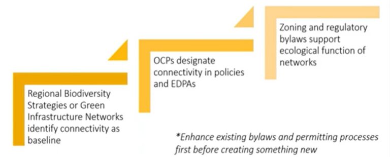
Figure 1: Nested approach to building habitat connectivity into a policy framework (source link)
In general, local governments will achieve stronger support, and possibly greater success, if they embed climate and environmental objectives throughout their policies, from coarse scale to fine. Local governments can embed goals for ecological protection, connectivity, and carbon storage in a Regional Growth Strategy (RGS) or Official Community Plan (OCP), provide specific and more detailed direction through a biodiversity strategy or green infrastructure strategy, and then engage in more specific implementation such as through developing EDPAs.
Public support for EDPAs and other green bylaws tends to be stronger when these are brought in as part of a broader OCP review or Biodiversity Strategy, rather than presenting them in isolation as a new initiative. EDPAs are inherently political, as they affect different properties in different ways; therefore, they need to connect within a broader policy and regulatory framework to withstand critiques based on the perception of private property rights.
References
- Curran et al, s. 9.9.1, pg. 125.
- Green Bylaws Toolkit 101, webinar 2021
Regional Growth Stategies
Regional Growth Strategies (RGS) are enabled under the Local Government Act Part 13. Under section 428(1), the purpose of an RGS is to promote human settlement that is socially, economically and environmentally healthy and that makes efficient use of public facilities and services, land and other resources. An RGS is a voluntary consensus-based regional land use planning policy document coordinated by a regional district for its member municipalities. It is developed collaboratively between local governments, with engagement of the province, First Nations, other public bodies, the public, and business and community stakeholders. An RGS should address regional issues such as transportation, economic development, housing needs, settlement patterns, and environmental goals with a 20-year timeline. All regional district bylaws and plans, and all OCPs of member local governments, must be consistent with the RGS.[1],[2]
LGA section 428 sets out the goals an RGS should work toward. One is to protect environmentally sensitive areas (ESA) [s.428(2)(d)]; another is good stewardship of land, sites and structures with cultural heritage value [s.428(2)(n)]. Local governments can use an RGS to get agreement on acquiring priority ESAs as parkland and to designate regional greenways and habitat corridors. An RGS can also incorporate regional conservation plans and other regional documents that detail the protection of green infrastructure. Many RGS either identify or make reference to the importance of urban containment boundaries, which can be crucial for protecting green infrastructure. An RGS may also promote integrated watershed management involving several local governments[3] or raise the profile of regional issues. Each of these should be based on recent and high-quality mapped information.
Jurisdiction
As described in section 4.4.3, Regional Growth Strategies (RGS) are enabled under the Local Government Act (LGA) Part 13. An RGS is a voluntary, consensus-based regional land use planning policy document coordinated by a regional district for its member municipalities. An RGS should address regional environmental goals with a 20-year timeline. All regional district bylaws and plans, and all OCPs of member local governments must be consistent with the RGS.
A well-crafted RGS can drive the protection and development of ecological networks across jurisdictional and ownership boundaries by designating biodiversity corridors. Objectives and policies for ecosystem protection should be stated. This helps raise the profile of regional ecological values and explain links between sensitive ecosystems and biodiversity to programs such as waste management, water conservation and responses to climate change. An RGS should recommend that protection of these ecosystems be incorporated into municipal OCPs, green infrastructure planning, watershed planning, biodiversity conservation strategies, environmental management systems and corporate strategic and operational documents.
An RGS may also identify land acquisition priorities and may itself include a regional biodiversity conservation plan (see section 5.8). Almost all RGSs in the province contain urban growth boundaries and policies to direct new development into serviced or near urban areas, with the aim of leaving rural and natural landscapes less disturbed. An RGS can also enhance the effectiveness of stewardship initiatives and facilitate collaborative financing.
RGS policy provisions
To support biodiversity and protect connectivity, an RGS should at a minimum contain policies that:
- clearly define “urban” and “rural” in terms of lot size and density;
- contain urban areas, and direct development and density into already serviced areas;
- protect rural landscapes from fragmentation;
- include maps designating land into classes or categories, including sensitive ecosystems, regional greenway or biodiversity corridors, unprotected green space, and priority parkland acquisitions;
- cluster development away from ESAs and SAR; and
- enable development of a regional biodiversity conservation strategy.[4]
- Incorporate nature-based solutions to protect communities from natural hazards such as drought, flood, storms and heat domes.
TABLE 6 provides examples of policy text drawn from existing Regional Growth Strategies in the project area. In most cases, these are policies that member municipalities have adopted in their bylaws.
[1] BC Climate Action Toolkit website, 2021, “Regional Growth Strategy”, https://www2.gov.bc.ca/gov/content/governments/local-governments/planning-land-use/local-government-planning/regional-growth-strategies, accessed 28 May 2026.
[2] Local Government Act Part 13, https://www.bclaws.gov.bc.ca/civix/document/id/complete/statreg/ r15001_13#part13 , accessed 28 Jan 2025.
[3] Curran et al, Green By-laws Toolkit, s. 5, pp. 43-46.
[4] Garry Oak Ecosystems Recovery Team. 2014. Model Bylaws for the Protection of Garry Oak and Associated Ecosystems. Victoria, B.C. 187 pp. Available at https://goert.ca/wp/wp-content/uploads/GOERT-Model-Bylaws-2014.pdf
Regional Conservation Strategies
Although a RGS may include environmental goals, its primary function is to guide regional growth. In some regions, a Regional Conservation Strategy (RCS) or plan may be warranted. An RCS can describe ecological principles and conservation goals and actions aimed at maintaining and enhancing the biological diversity of a region and protect or restore ecologically significant areas. This involves establishing a geographical framework for the strategy by mapping and analyzing habitat types, rare and significant species and ecosystems, and other biodiversity values.
An RCS should be based on a sound scientific foundation for conservation goals and objectives and provide local and senior governments and other stakeholders with management priorities and planning tools that can help them make decisions that ensure local habitats persist as viable elements of healthy regional watersheds and ecosystems. If an RCS is part of an OCP or RGS, all bylaws must be consistent with it. [1]
Unless well-crafted, implementing an RCS can face several challenges, such as the need for agreement among member municipalities and the regional board, which may lead to compromises on ecological goals and actions. In many cases, regional board members and municipalities have been unwilling to allow a regional document influence local action significantly, particularly those related to land use planning.
However, an RCS can offer advantages: it promotes a big-picture, landscape view of the region as a whole and provides a framework for considering conservation options for entire ecosystems and watersheds. This presents opportunities for collaboration among municipalities on conservation efforts, often with cost-saving benefits. For example, an RCS can consider the whole extent of a riparian corridor that crosses municipal boundaries. Land use planning that reflects this larger view and considers the wellbeing of whole ecosystems can make effective use of shared resources and significantly reduce the jurisdictional fragmentation that plagues many regional districts.[2]
Case Study 1: Islands Trust Conservancy Regional Conservation Plan 2018-2027
Established in 1990, the Islands Trust Conservancy (ITC) is a land trust and part of Islands Trust. The ITC is dedicated to preserving and protecting the fragile and unique ecosystems of the Islands Trust Area in the Salish Sea. This region includes 450 islands between southern Vancouver Island, mainland BC, and Howe Sound.
The ITC’s Regional Conservation Plan (“the plan”) provides detail on land status and land use, current ecosystems, protected areas and changes to the landscape over the last ten years, and sets conservation goals and objectives for the next ten years. The plan is science-based and community-informed, applying ecosystem values, threats, and current levels of conservation.
The ITC uses the plan as a tool to focus staff, board, and financial resources on areas with the highest biodiversity values and greatest need for conservation. Although its use is not embedded in Island Trust’s policy, it is sometimes used by Islands Trust decision makers to support ecologically responsible land use planning and is a resource for citizens and organizations working towards conservation of biodiversity within the Islands Trust Area. For more information, see ITC’s Summary of the Regional Conservation Plan (2018-2027).[3]
Regional conservation (or biodiversity) strategies (RCS) are enabled under the Local Government Act Parts 13 and 14 and can be part of an RGS. As described in section 4.4.4, an RCS differs from an RGS in that it promotes a landscape-level view of a region as a whole and provides a framework for considering conservation options for entire ecosystems and watersheds. This regional view encourages thinking beyond municipal boundaries and presents opportunities for collaboration among municipalities on conservation efforts, often with cost-saving benefits. For example, an RCS can consider the whole extent of a riparian corridor that crosses municipal boundaries. A well-crafted RCS will be based on agreement among member municipalities and the regional board; however, this may lead to compromises on ecological goals and actions.
Although RCS are not often used as a regional tool, they in fact represent the level at which ecological and climate resilience planning should take place. Metro Vancouver’s Climate 2050 Nature & Ecosystems Roadmap [4] provides a good example that other regional districts may draw from. It lays out 31 actions for storing carbon and increasing resiliency, organized under five strategic areas. The Roadmap also includes goals and specific targets. It acknowledges that working closely with First Nations, the federal and provincial governments, member jurisdictions, and other key partners is critical to effectively implementing and achieving these. Table 7 captures the five themes and 31 actions.
Table 7. Metro 2050 Nature & Ecosystem Roadmap themes and relevant actions (source link).
| A. Protect, restore, and enhance the region’s ecosystems | |
1. Protect an additional 10% of the region for nature. 2. Continue to implement the Regional Parks Land Acquisition 2050 strategy to increase the amount of important natural areas protected in the Regional Parks system. In regional parks and the drinking water supply areas, continue to restore and enhance degraded sites, enhance biodiversity, and promote ecosystem resilience. 3. Protect, restore, and enhance natural areas at the local scale through measures such as land acquisition, density bonusing, development permit requirements, subdivision design, conservation covenants, land trusts, and tax exemptions. (Adding green infrastructure planning and nature-based solutions to this statement is desirable.) 4. Incorporate climate change planning into protected area management 5. Advocate to the BC Government to make ecosystem health and biodiversity conservation the overarching priority of forest management and implement the recommendations of the strategic review of old forest management. 6. Provide data, guidance materials and best practices to inform the protection, restoration, and enhancement of ecosystems in the region. 7. Advocate to other levels of government and other agencies to commit to ecosystem restoration and enhancement at a significant scale to reverse the loss of the region’s ecosystems. 8. Support regional invasive species management by tracking disposal options, and working with researchers to improve the understanding of the potential spread of invasive species as our climate continues to change. Employ best practices to prevent the introduction and spread of invasive species on lands managed by Metro Vancouver. | |
| B. Connect green infrastructure | |
1. Develop a regional green infrastructure network. 2. Support the greening of urban areas by developing and sharing best practices and guidelines to incorporate green infrastructure into new developments and redeveloped areas. 3. Green the regional greenways network by incorporating green infrastructure, restoration of ecosystems and unprotected natural areas in greenway planning and design. 4. Minimize ecosystem fragmentation 5. Develop data and resources to support ecosystem connectivity | |
| C. Integrate natural assets into conventional asset management and decision-making processes | |
1. Incorporate natural assets into asset management and financial planning. 2. Integrate ecosystems and their services into the design of major infrastructure. 3. Consider ecosystems and their services in major development decisions. 4. Support natural asset management at the local level. 5. Explore the legal landscape and other barriers that may inhibit natural asset management. | |
| D. Support a resilient, robust, and healthy urban forest | |
1. Achieve 40% tree canopy cover within the region’s urban areas 2. Provide and share data and resources to support urban forest management. 3. All member jurisdictions, through implementation of the regional growth strategy, will enable the retention and expansion of urban forests using various tools, such as local tree canopy cover targets, urban forest management strategies, tree regulations, development permit requirements, land acquisition, street tree planting, and reforestation or restoration policies, with consideration of climate resiliency. | |
| E. Advance nature-based solutions to climate change | |
1. Explore the viability of innovative financial and incentive mechanisms (such as nature-based carbon offsets and credits, conservation levies, green bonds, insurance-based funding, and payment for ecosystem services. 2. Plan for climate change impacts on ecosystems. 3. Advocate that member jurisdictions include nature-based solutions in climate action plans. 4. Support the implementation of nature-based solutions by working with academic institutions and other regional partners. 5. Advocate to the BC government to continue implementing measures that adapt forests to a changing climate 6. Work with partner organizations to advance cross-jurisdictional nature-based solutions to address flood hazards 7. Work with academic institutions and other regional partners to better understand long-term health and blue carbon storage potential in the region’s coastal and marine ecosystems (tidal marshes, eelgrass, kelp, etc). 8. Work with key partners to address climate change issues in coastal and marine ecosystems. | |
[1] Curran et al, s. 6, pp. 48-49.
[2] Curran et al, s. 6.1, pg. 49.
[3] Islands Trust Conservancy, 2018, Regional Conservation Plan 2018-2027,
[4] MetroVancouver. 2023. Climate 2050 Roadmap: Nature & Ecosystems. https://metrovancouver.org/services/air-quality-climate-action/Documents/climate-2050-nature-and-ecosystems-road-map.pdf,accessed March 2025.
Official Community Plans
Official Community Plans (OCP) are enabled under the Local Government Act sections 471-475, 477-478 and are adopted as a local government bylaw. An OCP articulates a community’s objectives and policies regarding land use, community development, and operations. Comprehensive updates are required every five years; this should keep OCPs aligned with changing conditions. Under the LGA, OCPs may contain policies for the “preservation, protection, restoration and enhancement of the natural environment, its ecosystems and biological diversity.”
OCPs also act as links between an RGS and local land use decisions due to the requirement that there is consistency between regional bylaws and the RGS. Any development proposals, works, or projects undertaken, whether by the local government or private proponent, must be consistent with the OCP. Therefore, the more specific and detailed the OCP policies are, the more direction landowners and staff will have about public expectations for conservation.
Table 8 provides examples of OCP policy text drawn either from existing OCPs or from legally vetted publications.
Environmental Strategies
Local governments often enact environmental strategies that set out why and how they will deliver on policies and principles set out in an OCP, RGS, or RCS. Strategies may be specific to such issues as biodiversity, climate adaptation, land and parks acquisition, urban forests, or watershed management. Ideally, they will clearly integrate with broader policies and plans as well as implementation tools, such as bylaws (see the nested approach described in section 4.4.1).
Environmental strategies in general will:
- provide a vision statement;
- describe the context of the jurisdiction (ecological, geographic, cultural, economic etc.);
- set out guiding principles and objectives that mirror those in the OCP or RGS and links to existing or amended bylaws if enforcement might be necessary;
- show how the strategy is linked to other policies, including cross-jurisdictional ones;
- set out specific actions and an implementation plan (this might be in a separate action plan);
- set out a monitoring, assessing, and reporting framework, including performance indicators.
The Biodiversity Atlas provides information that local governments can use to inform such strategies and, when implemented, to track performance and adapt actions as needed.
References
- Bill 44 Housing Statutes (Residential Development) Amendment Act 2023.
- Government of British Columbia, 2023, Provincial Policy Manual & Site Standards, https://www2.gov.bc.ca/assets/gov/housing-and-tenancy/tools-for-government/local-governments-and-housing/ssmuh_provincial_policy_manual.pdf
- Government of British Columbia, 2023, Provincial Policy Manual & Site Standards, Part 1, s. 7.9, pg 25.
- Government of British Columbia, 2023, Provincial Policy Manual & Site Standards, Part 3, s. 1.3, pg. 50.
- Enns, J., 2024, Small-Scale Multi-Unit Housing Zoning: Legislation and Best Practices, report prepared for the Lidstone & Company Housing Needs – Legal Workshop held February 7, 2024, 192 pp.
- Enns, J., 2024, s. 2.3, pg 10.
- Riparian Areas Protection Act, SBC 1997, CHAPTER 21, https://www.bclaws.gov.bc.ca/civix/document/id/complete/statreg/00_97021_01, accessed 7 Jan 2025.
Zoning Bylaws
Zoning allows local governments to regulate the uses a landowner can put on a piece of land and how much of that use (i.e., density) is allowed on a specific part of the land. Whether on a municipal, regional district, or watershed level, zoning is the primary means of preventing development in locations where it can harm sensitive ecosystems and ecosystem connectivity.
Zoning for conservation is the most straightforward way to direct development away from carbon storing ecosystems and areas of biodiversity value. Once mapping has identified such locations, zoning can be used to create larger lot sizes and setbacks to maintain undeveloped landscape-level corridors.
Example Provisions:
- The setback adjacent to ponds, lakes, and wetlands shall include the bed and area between the water’s edge and a perpendicular line inland 30 metres (49.2 feet).
- No building, structure, road, parking lot, or other impermeable surface shall be located within a setback.
- The depth of each parcel created by subdivision that abuts a watercourse DPA shall be at least 20 metres.
References
- Riparian Areas Protection Act, SBC 1997, CHAPTER 21, https://www.bclaws.gov.bc.ca/civix/document/id/ complete/statreg/00_97021_01, accessed 7 Jan 2025.
- Ministry of Forests, Lands, and Natural Resource Operations, 2016, Riparian Areas Guidebook for Local Governments, 33 pp., https://www2.gov.bc.ca/assets/gov/environment/plants-animals-and-ecosystems/fish-fish-habitat/riparian-areas-regulations/rar-guidebook-local-government_web_final_aug_2016.pdf, accessed 3 Feb 2025.
- Ministry of Forests, Lands, and Natural Resource Operations, 2016, Riparian Areas Guidebook for Local Governments.
- Ministry of Forests, Lands, Natural Resource Operations and Rural Development Fish and Aquatic Habitat Branch, 2019, Riparian Areas Protection Regulation Technical Assessment Manual, https://www2.gov.bc.ca/assets/gov/environment/plants-animals-and-ecosystems/fish-fish-habitat/riparian-areas-regulations/rapr_assessment_methods_manual_for_web_11.pdf, accessed 3 Feb 2025.
Environmental Development Permit Areas
Under the Local Government Act s. 488 (1)(a), local governments can designate environmental development permit areas (EDPAs) for the protection of the natural environment, its ecosystems, and biodiversity. EDPAs provide local governments with an operational tool for managing development on a site-specific basis.
A development permit for an EDPA can specify areas of land that must remain free of development, require dedication of natural watercourses, and impose conditions on the sequence and timing of construction.
Case Study: District Municipality of West Vancouver
The District of West Vancouver has three types of Natural Environment and Hazard Development Permit Areas. These have been updated to reflect the 2023 provincial SSMUH requirements. West Vancouver’s EDPA works toward the principle of no net loss to balance unavoidable habitat losses with habitat replacement.
References
- Water Sustainability Act, SBC 2014, CHAPTER 15, https://www.bclaws.gov.bc.ca/civix/document/id/complete/ statreg/14015, accessed 21 Jan 2025.
- Water Sustainability Regulation, https://www.bclaws.gov.bc.ca/civix/document/id/complete/statreg/36_2016, accessed 21 Jan 2025.
- BC Government, 2022, “A User’s Guide for Changes in and About a Stream in British Columbia”, https://www2.gov.bc.ca/assets/gov/environment/air-land-water/water/working-around-water/wsa-cias-users_guide.pdf, accessed 21 Jan 2025.
- Curran et al, s.16.12, pg. 185.
Tree Protection Bylaws
A tree protection bylaw is an especially important tool for coastal communities and those where tree cover is a central part of the green infrastructure. Municipalities have broad jurisdiction to regulate, prohibit, and impose requirements through a tree protection bylaw enabled under Community Charter ss.8(3)(c), 15 & 50. This authority does not apply, however, to land and trees governed by a tree farm license, permit, or tenure under forestry legislation (e.g., PMFLA); or tree cutting that a utility undertakes on its land for purposes of safety or operating the utility. [1] Under LGA s. 500, Regional Districts have the authority to establish a tree cutting permit bylaw in relation to areas affected by flooding or other hazards.
The definition of “protected tree” varies across local governments, as do the criteria used to define them. Some criteria include height, diameter at breast height, significant trees, wildlife trees, species, replacement trees, covenanted trees, or trees in a certain area. For more examples of criteria and definitions currently used in tree bylaws in BC, see Tree Protection Bylaws in British Columbia (McLean 2021). [2]
Provisions in tree protection bylaws typically list different tree species and types of trees (e.g., wildlife trees, trees in riparian corridors, trees protected by a conservation covenant, trees of a specific diameter at breast height or larger) that require a permit to be cut or removed. Prohibitions may be placed on cutting trees in riparian corridors, ESAs, on floodplains, or in steep-slope areas. The bylaw may also prohibit damaging trees, for example by placing a toxic substance on the tree or by placing impervious surfaces within a minimum distance from the drip line.
If a tree permit is issued, the bylaw can enable imposing conditions in the permit such as specifying trees to be cut or removed, supervision of a certified arborist, planting and species of replacement trees, and/or use of specific forms of tree protection. [3] As more urban forest assessments and strategies are developed, a replacement ratio of 2:1 or 3:1 is becoming a common provision for trees cut under permit. With the climate-driven increase in storm events and tree stress, concern for hazardous trees has also increased. This can be addressed through policy that stipulates how trees should be assessed and managed, to help avert unnecessary cutting.
Policy Provisions
When well-written and enforced, with limited discretion in interpretation and application, a tree protection bylaw can yield many benefits from protecting specific rare trees or specific areas, to helping regenerate an urban forest and long-term rehabilitation of watersheds or landscapes. It can be used to set more stringent standards for sensitive ecosystems, and offer the opportunity for public education on importance of trees and native vegetation. [4] With accurate mapping information, staff can identify neighbourhoods or even specific trees that offer important environmental values such as habitat connectivity or wildlife trees.
A well-crafted tree protection bylaw is an effective tool that local governments can implement to help avert disturbance or destruction of forests, particularly on private land. Such bylaws have the co-benefit of conserving terrestrial carbon, sensitive ecosystems, connectivity, and SAR.
Tree protection bylaws are more effective when they provide specifics, for example regarding tree condition and location in relation to natural assets, and not just species and diameter at breast height. Municipalities have the power to apply tree protection bylaws to most private lands within their jurisdiction, whereas regional districts and Local Trust Committees in the Islands Trust area only have the power to apply tree protection bylaws to specific tree cutting permit areas based on hazardous conditions.[1]
At minimum, tree bylaws should require a replacement ratio of 1:1 for large trees and 2:1 for small trees, and a preference for native species or non-native species that do not exhibit invasive tendencies or that are drought-intolerant.
The following are examples of tree bylaws in use:
- Metro Vancouver Regional District offers a Tree Regulations Toolkit to assist local government staff and decision-makers inselecting regulatory tools to help achieve municipal tree preservation or canopy growth objectives.
- District of Saanich Tree Protection Bylaw
- District of West Vancouver Tree Bylaw
The following are examples of tree protection bylaw contraventions and fees currently in use by local governments. It is important to note that, in most municipalities, fees for tree bylaw contraventions are entirely inadequate. The fees shown here are among the highest in the project area and are still far too low to be a deterrent.
- Cutting down a tree in steep slope area – $500
- Damaging a protected tree – $300
- Pruning a significant or protected tree – $300
- Removing tree protection barrier – $300
- Working too close to a protected tree – $300
[1] Curran et al, 2021, s. 10.5, pg. 130.
[2] McLean, A, Tree Protection Bylaws in British Columbia: An overview of tree bylaws in BC and an assessment of their applicability in the Islands Trust area. 56 pp. Available at https://www.raincoast.org/wp-content/uploads/2021/08/tree-protection-bylaws-in-bc-2021.pdf. Accessed 26 Sept 2024.
[3] Curran et al, s. 15.6.2, pg. 170.
[4] Curran et al, s. 10.2, pg. 127.
References
- Curran et al, s. 29.2.3, pg. 306.
- Weed Control Act, RSBC 1996, c 487, https://www.bclaws.gov.bc.ca/civix/document/id/complete/statreg/ 96487_01#section2 , accessed 24 Jan 2025.
- Community Charter, SBC 2003, c 26, https://www.bclaws.gov.bc.ca/civix/document/id/complete/ statreg/03026_00, accessed 24 Jan 2025.
- Community Charter, Spheres of Concurrent Jurisdiction—Environment and Wildlife Regulation, BC Reg 144/2004, https://www.bclaws.gov.bc.ca/civix/document/id/crbc/crbc/144_2004, accessed 24 an 2025.
Riparian Protection
As described in Section 4.3.4, the Riparian Areas Protection Regulation (RAPR) directs local governments to protect riparian areas during residential, commercial and industrial development, through the use of their authority outlined in Part 14 of the Local Government Act (LGA). The RAPR establishes a science-based process that local governments can apply to achieve riparian area conservation. Although RAPR focusses on riparian fish habitat, local governments are free to use their powers under the LGA to protect other values.
Local governments have three general options for implementing RAPR:
- Set out riparian assessment areas for a stream (Streamside DPAs), following RAPR Section 8.
- Establish a rules-based scheme or an approvals-based scheme that prohibits a development from proceeding unless certain conditions are met, following direction of RAPR Section 4.
- Establish a regime that provides a level of protection that meets or exceeds RAPR. Some municipalities have adopted this approach.
Table 4 lists the various legal tools available to local governments to protect watercourses and riparian areas from disturbance. The options chosen will depend on a local government’s goals, the nature of information it has available regarding streams in its jurisdiction, and in part on staff capacity.
Table 4. Local government legislative tools for implementing RAPR (source)
| Tools | Legislative authority |
|---|---|
| OCP | Local Government Act, Part 14 |
| Development Permit Areas | Local Government Act, Part 14 |
| Zoning bylaws | Local Government Act, Part 14, Land Title Act, Part 7 |
| Development approval and information bylaws | Local Government Act, Part 14 |
| Covenants | Land Title Act |
| Other regulatory bylaws affecting land use | Local Government Act, Part 9, and Community Charter |
Whichever tools a local government chooses to use, there are three elements that their regulatory process needs to provide:
- definitions of streams and riparian areas that are consistent with RAPR;
- a means of triggering a regulatory action if a development activity is proposed to occur in a riparian assessment area; and
- a means of requiring a QEP assessment report that complies with the RAPR and its assessment methods.
The RAPR has the expectation that the local government’s development approval mechanism, using such tools as rezoning or subdivision approvals, development permits, building/variance permits and others, will be subject to the conditions outlined in the RAPR assessment report, including the delineation and protection of the SPEA and incorporation of all applicable measures in the report.
Non-legislative tools available to local governments for the protection and conservation of riparian areas include information and education about stream stewardship, watershed or stormwater management plans, parkland acquisition, tax incentives, and landowner agreements such as covenants.
References
1. BC Government website, “Forest Landscape Plans”, https://www2.gov.bc.ca/gov/content/industry/forestry/ managing-our-forest-resources/forest-landscape-plans, accessed 28 Jan 2025.
Park Land Acquisition Tools
References
[1] Private Managed Forest Land Act, SBC 2003, c 80, s. 21, https://www.bclaws.gov.bc.ca/civix/document/id/ complete/statreg/03080_01, accessed 21 Jan 2025.
[2] Curran et al, s. 29.4, pg 317.
Acquiring parkland is an important strategy for protecting environmentally sensitive areas and high carbon ecosystems, and for providing a community with opportunities to connect with the natural environment. OCPs often establish land acquisition policies in relation to parks master plans. Park land can either be purchased using funds from Development Cost Charges (DCCs), Amenity Cost Charges (ACC donated through Community Amenity Contributions (CACs) and Density Bonuses, LGCAP and Parks / Land Acquisition Funds.
Development Cost Charges
Development Cost Charges (DCCs) are required fees that are paid on all new development to aid with the costs associated with infrastructure that is required to service growth across a municipality or region. The Local Government Act states that DCC funds can be used only for specific types of infrastructure, one of which is acquiring park land or reclaiming land as park land. [1]
DCCs can therefore bolster a parkland acquisition budget and can be enabled through the adoption of a DCC bylaw for the specific acquisition of ESAs or green infrastructure. However, acquiring park land in this way often will not meet a local government’s conservation goals, given limited land acquisition budgets and the growing gap between land values when DCC rates were calculated and land values today. CACs and Density Bonusing can be used to help fund amenities that cannot be funded through a DCC program.
Case Study: Metro Vancouver parklands acquisition
Metro Vancouver has a long history of protecting its natural assets through land acquisition to create regional parks. The acquisition of parks from 1969 to 1993 was funded through a tax levy collected within departmental budgets, borrowing and provincial government contributions. In 1993 a Parks Acquisition Fund was established and is still in place, which is funded by a tax requisition. The acquisition of parklands is guided by the ‘Regional Parks Land Acquistion 2050’.
In 2019, Metro Vancouver produced their Climate 2050 Strategic Framework, which indicated the intent to produce roadmaps for emissions sources and routes of reductions. This led to the Nature and Ecosystems 2050 Roadmap, which included a goal to protect 50% of the region for nature by 2050, in part to help attain Metro Vancouver’s target to be carbon neutral by 2050. In response to increasing land prices and its strategic direction to purchase more land for parks, in 2025 Metro Vancouver is going to start collecting a DCC for new residential and non-residential developments to pay for new parks for future occupants. This will supplement the fund raised by the Parks Acquisition Fund. These funds will be collected by the municipalities at the subdivision stage or building permit stage.
Amenity Cost Charges
The Housing Statutes (Residential Development) Amendment Act 2023 established an Amenity Cost Charge (ACC), formalizing a development finance tool that has historically been voluntary (referred to as Community Amenity Contributions). This tool allows local governments to collect funds for amenities like community centres, recreation centres, daycares, and libraries from new development that results in increased population. Local governments are exploring using this tool as an additional way to buy parks (e.g. North Vancouver). To bring in ACC local governments need to establish a bylaw.
Community Amenity Contributions
CACs are voluntary contributions agreed to by a developer and a local government (e.g., City of Nanaimo) as part of a rezoning process. When a property is rezoned to enable an increase in density or a change in use, there is often an associated increase in land value. CACs have been used to help a local government address the costs of growth-related community amenities, such as affordable housing, greenspace, cultural amenities, and emergency services. CACs can improve the efficiency of local government expenditures by acquiring green space with little or no direct cash outlay. They can facilitate site design that is ecologically sensitive and shifts some green space conservation costs onto the development industry.
Since enactment in 1993, CACs have faced controversy. Many believe they allow developers to purchase additional density that overrides what a community has agreed to in its OCP. Given current property values and building costs, the amount of additional density needed to generate enough of a bonus to purchase or secure an amenity can be significant. This can lead to landscape fragmentation if it occurs in or near greenways or significant ESAs. Other challenges include unfavorable real estate markets; poor lines of communication between local government planners and developers; establishing an acceptable exchange value; protracted negotiations and uncertainty in the approval process; and political resistance to higher density. [3]
Density Bonus
A Density Bonus is the additional density that can be built in exchange for providing an amenity contribution. The developer benefits from the additional floor space or units, and the community benefits from obtaining a public amenity. Density Bonus provisions may be included in zoning bylaws, or they can be part of OCP policies that are negotiable on a case-by-case basis. [2] Local governments have used Density Bonuses with other techniques, such as clustering development and conservation covenants, to protect ESAs or other green infrastructure features.
Under the Local Government Act, local governments can require landowners to dedicate up to 5% of the land being subdivided for parks, but many developers are willing to work with local governments to craft unique responses to site-specific ecosystem conditions and development costs.
Amenity zoning can, however, be a useful tool for protecting lands for conservation and carbon storage. Medium to small communities have used the density bonus and rezoning for subdividing large parcels to achieve the protection of parkland along with residential clustering.
- The rural District of Highlands has used the density bonus since the District adopted its first OCP in 1997. The OCP policy states that public amenities may be offered through rezoning to justify an increase in density. Such amenities must be beneficial to the wider community, as well as the proposed development, and may be offered in recognition of the increased value of land resulting from rezoning. Proposed amenities include, among many others, protection of sensitive high value environmental areas by covenant. [4]
- The Islands Trust OCP for Salt Spring Island includes a policy stating that the protection of ESAs or high biodiversity areas is an eligible community amenity, which could be exchanged for a higher density of development. [5]
Environmental levies
Local governments may need to establish funds to pay for costs associated with climate mitigation and adaptation. One method is through environmental levies. For example, in 2022, the District of West Vancouver established an Environmental Levy to fund climate change mitigation and adaptation measures. The levy contributes to the Environmental Reserve Fund which is intended for: a) programs that support the protection of the natural environment; b) climate change response, mitigation, and adaptation; c) sustainability and protection of the District’s natural capital assets; and d) reduction of GHGs both by corporate operations and the community. Biodiversity mapping can help local governments determine appropriate environmental levies by identifying climate risk areas and those that offer high ecosystem services and potential for nature-based solutions, such as flood mitigation.
[1] Local Government Act, s. 566(2)(b)(i).
[2] Curran et al, s. 8.6, pg. 87.
[3] Taves, L., 2002, Density Bonus as a Tool for Green Space Conservation, MSc Thesis, Simon Fraser University.
[4] District of Highlands Official Community Plan Bylaw No 277, 2007, https://highlands.bc.ca/ DocumentCenter/View/4080/Official-Community-Plan—Schedule-A—Bylaw-277—2021?bidId=,accessed 29 Jan 2025.
[5] Islands Trust Salt Spring Island Local Trust Committee Official Community Plan Bylaw No. 434, 2008, Schedule “A”, https://islandstrust.bc.ca/document/salt-spring-island-ocp-bylaw-no-434-2023/, accessed 29 Jan 2025.
Conservation Covenants
Even if all regulations and best management practices are followed, damage to ESAs by development activities is not uncommon. Local government can require developers to post a security deposit that the municipality can use for habitat restoration, if damage occurs. Under the Land Title Act s.219, a local government may register a conservation covenant on the title that applies to ecologically sensitive land (either lots or portions of lots) can also help protect ecological integrity by specifying what activities are permitted on the land and the features of the land that must be preserved.
A conservation covenant provides long-term protection on private land, and without the expense of purchasing land. It can be tailored to an individual ecological feature, leaving the rest of the property unrestricted. However, it can be costly to survey the land, develop the covenant, and register it. Also, the reason for the covenant may be rendered ineffective without ongoing monitoring and effective enforcement in place. New property owners may not be aware of or understand the covenant provisions, so ongoing education may be necessary. An effective solution is for a local conservation organization to hold the covenant and assume monitoring function; however, this requires an endowment to cover costs.[1]
[1] Curran et al, s. 14.3, pg. 157.
What to look for from QEPs
Land use planning and development must be based on sound ecological information to effectively protect the habitats necessary to maintain biodiversity. The identification and assessment of a site’s ecological attributes are essential as a first step in all land use planning processes. These should be identified early in the planning process to help plan for their protection.
Some local governments have enacted a bylaw to establish a Development Approval Information Area (DAIA) <see Sunshine Coast toolkit for discussion on rqmt for QEP to be open to challenge if no DAIA> over their entire jurisdiction. This bylaw enables them, during the development permit process, to require developers to hire a QEP to conduct a biological site inventory in accordance with guidelines before any land disturbance takes place and before development design begins. A DAIA can be used as a way for local governments to acquire site information. There are currently no provincial standards for urban biological site inventories in BC, but there are guidelines that local governments should require from developers and their QEPs, which are discussed below.
A biological inventory involves a preliminary site survey, which may lead to a detailed site inventory and report. QEPs who undertake such work are required under the Professional Governance Act [1] to have relevant skills, qualifications, and expertise to do such work, but local government staff may not have the background or time to evaluate the quality of such reports.
Comprehensive information regarding requirements for preliminary and detailed site inventories is provided in Develop with Care Appendix B Bio-inventory Terms of Reference.[2] While somewhat dated (there have been several regulatory changes since it was written in 2014), it details what should be included for both inventory types, and provides example checklists for both inventory types. Staff should refer to it as a cross-check to ensure QEP reports meet these standards.
In general, the following are considerations that staff should look for in site inventories and reports:
- Ensure the QEP can demonstrate that they have expertise in the ecological elements being observed, such as riparian ecosystems, plant and animal identification, or land cover mapping. In some cases, such as riparian areas, specialized training and certification are mandatory.
- Ensure the QEP has ability to identify species at risk and habitat that might occur or that were observed in the study area.
- Require the QEP to submit any observations of provincially or federally listed species to the BC Conservation Data Centre. The data will be kept confidential by the CDC if that is requested.
- Ensure the QEP visits the site at the appropriate times of year necessary to detect suspected or potential species at risk or species that may be protected under provincial or federal legislation.
- Ensure the QEP carries out full ground inventories and provides a map of ESAs observed at the site rather than just relying on previously mapped SEI data.
- Ensure the QEP follows established Resources Information Standards Committee (RISC) standards for inventorying and mapping and provides evidence that they have done so (e.g., describes standards followed, provides metadata).
- Require that QEPs make use of applicable best management practices, for example:
- Environmental Best Practices Guide for Wildlife in Canada
- Raptor Best Management Practices
- Develop with Care
[1] Professional Governance Act, SBC 2018, CHAPTER 47, https://www.bclaws.gov.bc.ca/civix/document/ id/complete/statreg/18047, accessed 1 Feb 2025.
[2] Develop With Care, 2014, Environmental Guidelines for Urban and Rural Land Development in British Columbia, Appendix B: Bio-inventory Terms of Reference, in Appendices, https://www2.gov.bc.ca/assets/gov/ environment/natural-resource-stewardship/best-management-practices/develop-with-care/dwc-appendices-a-f.pdf , accessed 30 Jan 2025.
Natural Asset Management
Natural assets such as forests, wetlands, watercourses, and grasslands contribute to the provision of municipal services to a community such as clean water, flood management, improved air quality, and improved biodiversity. Natural assets are a part of the broader category of green infrastructure. Local governments are increasingly recognizing the intrinsic and financial values of natural assets in their jurisdictions.
Establishing natural asset inventories provides baseline information for calculating values and determining what to protect and restore. This information, coupled with integrating natural asset objectives into policy, can guide planners when making land use decisions ranging from long-term and large scale to site specific development proposals. Natural asset management can help local governments improve climate resilience, environmental protection, and cost effectiveness relative to engineered assets.
To steward natural assets, each municipality needs to formulate a natural asset database, with policies that support the acquisition, protection and restoration of these assets. The Biodiversity Atlas is a resource for such databases and policies.
The following examples of natural asset approaches provide ideas to draw from:
- In 2022, the City of Colwood worked with the Natural Assets Initiative (NAI) to create an inventory of Colwood’s natural resources and provide a high-level condition assessment for each asset. This gives Colwood baseline information to build upon. The inventory used LiDAR data to identify the total area (hectares) of several different natural asset types. The results were used to populate a Natural Assets dashboard. Colwood is at an early stage of integrating asset management into policy and governance as it does not yet have a formal asset management program or policy in place. Senior management and Council are aware of the need to formalize an asset management program, as evidenced by the creation of the Natural Assets dashboard and Colwood’s Sustainable Infrastructure Replacement Plan.
- The District of Saanich is in the early stages of developing a natural assets management program. Saanich includes its natural assets under the broader category of green infrastructure. Asset Management Plans will be developed for natural assets as well as eight engineered asset types as depicted in Figure 11, below.
In 2024, a summary of enhanced natural asset inventory results and recommendations was submitted to Council for consideration. Saanich’s next step is to develop the Natural Asset Management Plan, which will further develop the information in the inventory, and also lifecycle management activities, costs and funding strategies for the natural assets that are owned and managed by the District. The Natural Asset Management Plan will be integrated with other Saanich initiatives, from strategic documents and plans to implementation initiatives (Figure 12).
Enforcement
Bylaw enforcement and ticketing by municipalities are enabled under the Community Charter, ss. 260, 264-265. Ticketing is the easiest method of enforcement; however, it does not necessarily result in continued compliance. There are three different processes by which local governments may issue tickets: the Municipal Ticket Information (MTI), the long-form prosecution in Provincial Court and the new Bylaw Dispute Adjudication System (see Community Charter Part 8).
Bylaws and permit requirements will be ineffective unless landowners and permit holders know that a local government will act in response to violations that affect important ecosystem values, and unless the local government is consistent in its enforcement and that fees that are appropriate for the infraction and number of repeated infractions.
Because bylaw enforcement in many communities is complaint-driven, establishing a policy and resources for an environmental bylaw monitoring program is one way to ensure compliance with bylaws and permit conditions in areas of ecological significance.
Strategic enforcement not only promotes compliance with specific requirements, but it also reinforces the importance of compliance more generally in the community as a whole. The goal is to set precedents and create a culture of compliance.
Example Watercourse Protection Fees:
- Fouling watercourse – $250
- Obstructing fish passage – $250
- Enclosing watercourse – $250
- Obstructing a watercourse – $350
- Failure to remediate discharge of prohibited substance – $500
Incentives
Provincial legislation gives local governments legal options for providing landowners and developers with incentives to meet the goals of biodiversity protection and enhancing climate resilience. They can offer property tax exemptions for riparian property secured with a conservation covenant on the title.
Innovative Incentive example: Islands Trust NAPTEP
A notable example is the Islands Trust Natural Area Protection Tax Exemption Program (NAPTEP). Administered jointly by the Islands Trust and the Islands Trust Conservancy, NAPTEP encourages landowners in the Islands Trust Area to voluntarily register conservation covenants on portions of their property and, in return, receive an annual 65% property tax exemption on the protected portion of the land.
The program’s success has inspired discussion around broader tax incentive frameworks for private land conservation in other jurisdictions across British Columbia.
References:
Education
The least expensive and most administratively efficient way to achieve bylaw compliance is to avoid the need for enforcement by using public education, engaging stakeholders, and developing regulations through public processes. Involving the community in development of environmental regulations is an opportunity to improve awareness and appreciation of the values being protected.
Similarly, by increasing community and landowner awareness of the value and benefits of ecological protection and the implementation tools their local government is using, better traction and compliance with protection measures may be realized.
Local governments can also implement public and commercial education through interpretive signage, workshops, social media, and direct outreach targeted at land developers.