First Nations
Land Use and Relationship Plans
Land-use planning is a process by which communities or governments develop a framework to guide decision-making about lands, waters, resources, wildlife and people who live in an area. This process can include an articulation of Indigenous laws and protocols for managing the land. It can also explore the linkages between language, place names and stewardship of the land.
There are a number of resources available to Indigenous Peoples to guide them in the development of a Land Use Plan. Two guidance documents have been provided below:
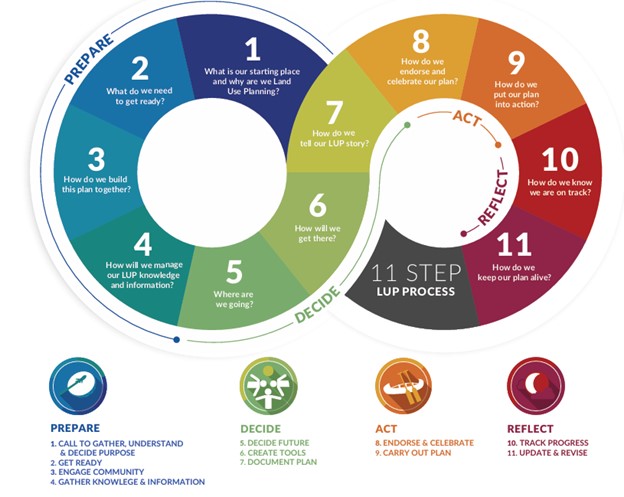
Land Use Planning Process shared in Our Sacred Lands
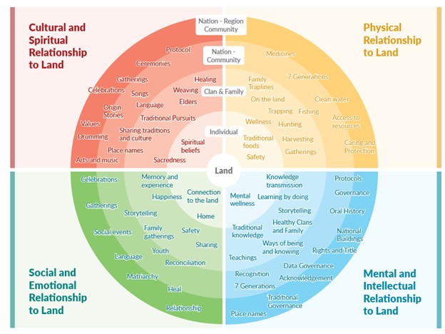
First Nations World View presented in Our Sacred Land
Description
Land Use Plans (or Land Relationship Plans) identify what is found on a First Nation’s lands or waters, what the First Nation’s aspirations and desired uses are for those lands or waters, and how they will be managed. Such plans can help First Nations determine for themselves the future of their lands while providing certainty for industry and nearby land owners. They do not need to be developed in partnership with provincial or federal government.
Approaches to Land Use Planning
A Land Use Plan is developed through community meetings, interviews with Elders, youth and other land users, and extensive data collection and analysis, communities identify which lands they want to protect and which lands could be zoned for development and resource use.
A land use plan can be preparation for or as part of a Land Code or IPCA process, or some other agreement process that includes provincial or federal government or other partner. In those cases, a collaborative table model might be considered.
In the case of a partnership IPCA approach, the Nation and the provincial government may choose to enter into a land use planning process together, where there is a shared interest in enacting the IPCA under both sets of laws and where such a partnership can meet both governments’ needs.
While there is no one template for a land use plan, they are typically based on data collected on the ground and in the community, such as presence of species of cultural value, wetland and watercourse presence and condition, wildlife presence, forest cover type, and include maps showing these attributes.
Case Studies
Communities that are considering establishing a Land Use Plan may benefit from contacting First Nations who have been through the process. Case studies have been provided below to provide a starting point.
Tla’amin Nation Forest Resource Plan
Tla’amin Nation underwent detailed consultation as well as mapping of its territory (using some of the Action for Adaptation maps) to develop its Forest Resource Plan.
The Tla’amin Forest Resource Plan sets out management direction for over 200,000 hectares of forestland in Tla’amin Territory including 8,300 hectares of Tla’amin Treaty Settlement Lands. This plan creates a predictable framework for the next 300 years so that the rights of people, animals and plants in Tla’amin Territory are respected and protected. The Plan coordinates stakeholders and addresses cumulative impacts of industry on water, plant and animal life across the Territory.
The Plan marks the resumption of Tla’amin Nation’s stewardship role across all of Tla’amin Territory. The Plan is built upon Tla’amin Law and fulfils requirements as outlined in the Tla’amin Forest Law.
Planning Process
A two-year holistic process was undertaken to develop the Plan.
Staff spoke with hunters, plant medicine experts, Elders and other Tla’amin harvesters to develop the plan and protect resources key to the sustainment of Tla’amin culture and teachings. The voices of Citizens who spend a lot of time on the Territory were prioritized through the two-year development process. Large forest tenure holders provided input into the Plan’s development to harmonize harvesting schedules and to minimize cumulative impacts.
The Plan includes standards for cumulative effects. For instance, right now there is limited provincial protection for small streams, but small streams feed big streams. This plan establishes buffers for small streams and increases the size of all stream buffers.
Importance of a long-term plan
Trees and ecosystems take a long time to grow and develop so long-term planning is critical. Reaching objectives like the reestablishment of old growth stands in key areas takes hundreds of years.
This plan models 300 years into the future. The Plan enables Tla’amin Nation to exceed 30×30 conservation area targets (by which 30% of available area is protected by 2030).
The Nation relies on Forestry revenues to fund critical programs and services so long-term revenue projections are important.
The Plan is an evergreen adaptive management plan. It will be reviewed within 1 year of implementation and audited annually thereafter.
Structure of the Plan
The plan specifies general stewardship measures for:
– Ecological Integrity
– Heritage and Culture
– Water and Aquatic Habitat
– Wildlife
It designates different management zones on the Nations’s territory:
– Ecosystem Health Zone – to manage for a high-level of ecological integrity at thenlandscape and stand-level to ensure the maintenance and restoration of ecosystem health, alongside the healing of Tla’amin cultural lifeways; this will be informed by the traditional resource management principles that respects the spirit of all living things and encourages a holistic interconnected view of the land. The Ecosystem Health Zone will be a focus area for future habitat and land use planning initiatives that increase ecosystem health.
– Investment Zone – to manage forests sustainably with a long-term investment focus to encourage high-value products while providing consistent economic benefit to the local community; the Investment Zone will be a focus area for future investment initiatives in stand quality improvement for timber and other identified forest assets.
– tiskʷət stewardship zone – to respect the cultural legacy and significance of tiskʷət as a cultural corridor throughout the connected waters of θayɛɬ, while enabling the restoration of salmon to the watershed; the tiskʷət Stewardship Zone will be a focus for future cultural and ecological restoration initiatives that serve to increase the Tla’amin cultural lifeways associated with this area.
– saʔyayɩn Stewardship Zone is to retain ecologically rare and endangered ecosystems with a focus on cultural plants; the saʔyayɩn Stewardship Zone will be a focus for future rare plant community identification and restoration projects, contemporary-use focus studies, and karst-based planning.
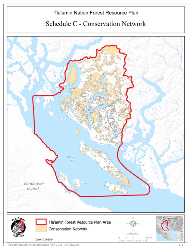
Tla’amin First Nation Forest Resource Plan Schedule C Conservation Areas